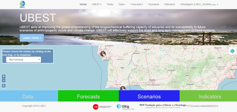
UBEST: Understanding the biogeochemical buffering capacity of estuaries relative to climate change and anthropogenic inputs

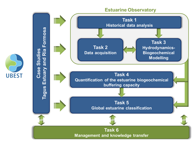
UBEST aims at improving the global understanding of the biogeochemical buffering capacity of estuaries and its susceptibility to future scenarios of anthropogenic inputs and climate change. UBEST will effectively support the short and long-term management of these systems. This goal will be achieved by deploying “observatories”, which are emerging tools that integrate process-based numerical models and their results, and in-situ observations. To promote the generalization of the conclusions, two Portuguese case studies with very distinct characteristics will be assessed, the Tagus estuary and the Ria Formosa, a coastal lagoon.
More InformationTask 1 – Historical data compilation and analysis
A background characterization of the Tagus estuary and of the Ria Formosa was performed providing a better understanding of the natural variability of these systems, and of their evolution and response to anthropogenic and climate drivers. This review is also the foundation of the historical environmental data compilation that will integrate the Tagus estuary and the Ria Formosa observatories.
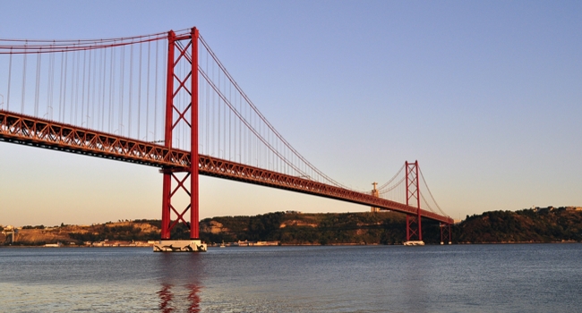
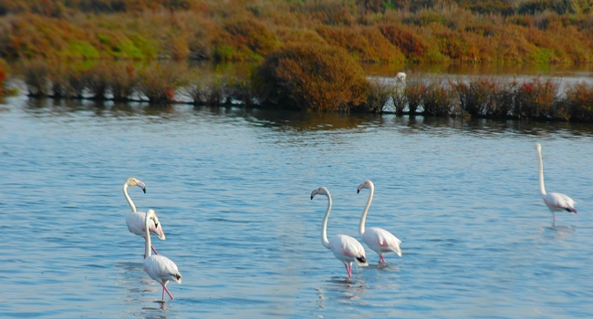
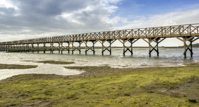
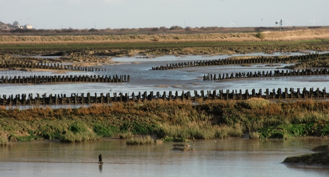
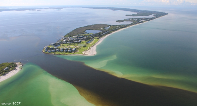
The ecological values of both systems are well recognized, as they both harbor important protected ecosystems. The Tagus estuary is one of the largest estuaries in Europe with an area of about 320 km2. The Ria Formosa is considered the most important coastal ecosystem in the Algarve region, with an humid area of about 100 km2 of which one third corresponds to saltmarshes. Both systems are vital for the local and regional economies supporting diverse activities along their margins and in their watersheds, like urban areas, industrial, port and airport facilities, fishing, tourism and aquaculture. The Tagus estuary and the Ria Formosa present, however, very distinct physical and morphological characteristics. One of the main differences relies on the freshwater input, which is almost negligible in the Ria Formosa, except in Tavira where the Gilão River encounters the sea. In contrast, in the Tagus estuary the mean freshwater input from its main affluent, the Tagus river, is 336 m3/s. Morphologically, the two systems are also significantly different. The Tagus estuary is a single inlet system, while the Ria Formosa is a multi-inlet system. These different characteristics affect the circulation within both systems and, consequently, the biogeochemical dynamics.
Find out more about the Tagus estuary and the Ria Formosa.
Task 2 – Monitoring network: conventional field campaigns and online station deployment and validation
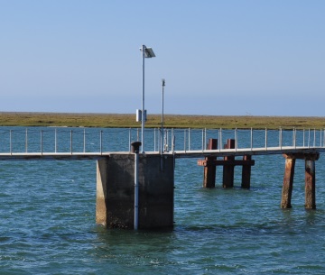
Online monitoring in the Ria Formosa
A water quality online monitoring station was installed and is under operation in the Ria Formosa, in the Faro channel, since May 2017. This station is equipped with an YSI EXO2 multiparameter probe, which measures water temperature, conductivity, pH, dissolved oxygen, turbidity and chlorophyll a, and an OBSERMET OMC-045-III data logger, for data acquisition and transmission.
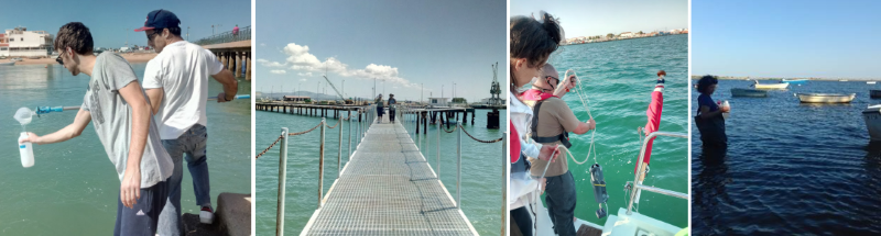
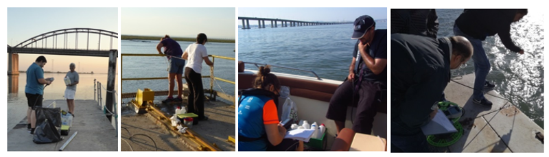
Field campaign – UBEST1
The first field campaign took place in the Ria Formosa on May 30-31, 2017. This field campaign covered the entire area of the Ria Formosa and included the collection of physical, chemical and biological data during one semidiurnal tidal cycle (~12.5 h).
Field campaign – UBEST2
The second field campaign took place in the Ria Formosa on September 14-15, 2017.
Field campaign – UBEST3
The third field campaign took place in the Ria Formosa on October 26-26, 2017.
Field campaign – UBEST4
The first field campaign in the Tagus estuary took place on May 10, 2018. This field campaign covered the entire area of the estuary and, similarly to the field campaigns in the Ria Formosa, included the collection of physical, chemical and biological data during one semidiurnal tidal cycle (~12.5 h).
Field campaign – UBEST5
The second field campaign in the Tagus estuary took place on September 27, 2018.
Field campaign – UBEST6
The third field campaign in the Tagus estuary took place on November 6, 2018.
Task 3 – Implementation, validation and operational deployment of the coupled hydrodynamic-biogeochemical numerical models
The 3D baroclinic hydrodynamic and biogeochemical models of the Tagus estuary and the Ria Formosa were implemented using the community modeling system SCHISM – Semi-implicit Cross-scale Hydroscience Integrated System Model (http://ccrm.vims.edu/schism/, version 5.4.0) and simulate several physical (e.g. water levels, salinity), chemical (e.g., inorganic nutrients) and biological (e.g., chlorophyll a) variables
The numerical model of the Tagus estuary is over 110 km long and has a surface area of 1442 km2. It extends from the ocean, 27 km away from the estuary mouth, to the river estuary (Portugal). The model was calibrated and extensively validated by comparison with field data. Overall, the results showed its ability to represent the main spatial and temporal patterns of circulation and water quality observed in the Tagus estuary.
The numerical model of the Ria Formosa covers the entire coastal lagoon and the adjacent coastal area. Similarly to the Tagus estuary model, the model was calibrated and extensively validated by comparison with field data and its results showed the model ability to represent the main spatial and temporal patterns of circulation and water quality observed in the Ria Formosa.
The Tagus estuary and Ria Formosa hydrodynamic and biogeochemical models were implemented operationally, providing daily forecasts of water levels, velocity, salinity, temperature, ammonium, nitrate, phosphate, silicate, dissolved oxygen and chlorophyll a (available in http://portla-ubest.lnec.pt). The forecasts are performed daily and the procedures are assembled in the forecast engine, a software built on top of the Water Information Forecast Framework - WIFF, a Python-based framework, that is also used to enable the on-demand forecast systems in the OPENCoastS service (https://opencoasts.ncg.ingrid.pt). Oceanic boundaries are forced by ocean forecasts, sourced from Copernicus’ CMEMS IBI_ANALYSIS_FORECAST_PHYS_005_001 and IBI_ANALYSIS_FORECAST_BIO_005_004 (http://marine.copernicus.eu/), for physical and biogeochemical variables, respectively. Riverine boundaries can be forced by extrapolations of quasi real-time data or climatology. Atmospheric forecasts sourced from NOAA’s GFS 0.25º are used as well (https://www.ncdc.noaa.gov/data-access/model-data/model-datasets/global-forcast-system-gfs).
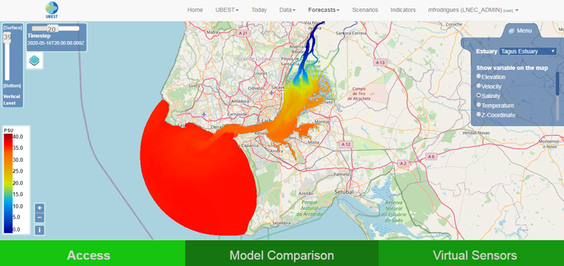
Salinity forecasts in the Tagus estuary
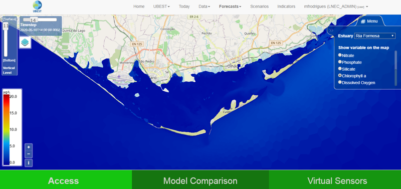
Chlorophyll a forecasts in the Ria Formosa
Task 4 – Quantification of the estuarine biogeochemical buffering capacity for present and future scenarios
Climate change and anthropogenic impacts
Several scenarios of climate change and anthropogenic pressures were simulated in the Tagus estuary and the Ria Formosa, using the validated hydrodynamic and biogeochemical models developed.
A reference scenario was established for Spring based on climatology estimated from the historical data. The future scenarios were established based on a literature review. For the Tagus estuary, the following scenarios were simulated: reference, sea level rise of 0.5 m, river flow decrease to 75% of the reference scenario, an increase of 100% in the nutrients loads at the riverine boundaries and a decrease of 50% in the nutrients loads at the riverine boundaries. For the Ria Formosa the scenarios were: reference, sea level rise of 0.5 m, increase of 1.6 ºC of the air temperature and an increase of 50% of the nutrients loads at the wastewater treatment plants.
The results from these simulations were summarized in maps of statistics (mean, minimum and maximum) that can be accessed through the web portal. To quantify the impacts, differences between the reference scenario and the other were also computed. For the scenarios, the TRIX trophic index was also computed allowing an integrated comparison and the resulting maps are available in the web portal. These results provide further insight about the systems response to changes in the main drivers and constitute an important database to support their management.
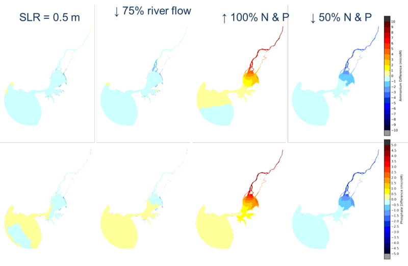
Ammonium and phosphate in the Tagus estuary – differences between the reference and the future scenarios
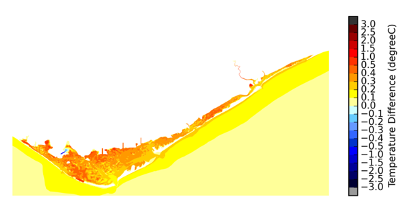
Water temperature in the Ria Formosa – differences between the reference and the future scenarios
Task 5 – Global estuarine classification
A literature review was performed to summarize both classical and new classification metrics for the circulation dynamics. Based on the review, a set of metrics was selected to classify the Tagus estuary and the Ria Formosa using an integrated data-modelling approach. The selected metrics were: the classification proposed by Geyer and MacCready (2014) to assess the circulation and the mixing conditions and the Venice system (after Carriker, 1967).
Similarly to the physical classification, a literature review was performed for the water quality indicators. The following indicators covering both national and international metrics were selected: nutrients status based on the benchmarks defined by Caetano et al. (2016) for the Portuguese transitional waters, chlorophyll a status based on the benchmarks defined by Brito et al. (2012a, b) for the Portuguese transitional and adjacent coastal waters, and the trophic index TRIX (Vollenweider et al., 1998). The water quality in the Tagus estuary was classified based on the data collected during the three main field campaigns performed in 2018 and an assessment of the long-term evolution of the water quality in this estuary was also done using both historical and recent data. The water quality in the Ria Formosa was classified based on the data collected during the four main field campaigns performed in 2017 and in 2019 and an assessment of the long-term evolution of the nutrients concentration have been done, through the comparison of these data with historical datasets over the past 40 years.
TRIX in the Tagus estuary (estimated based on 2018 field data)
TRIX in the Ria Formosa (estimated based on 2017 and 2019 field data)
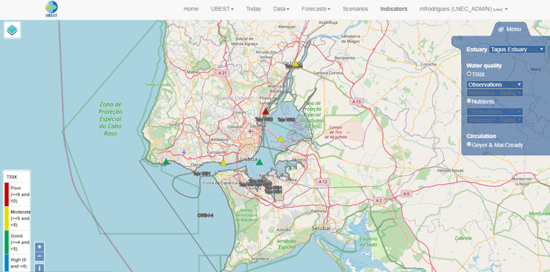
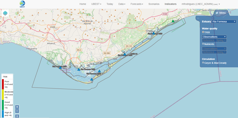
Web portal
Comprehensive web-portal that integrates the information of the water observatories, including: i) historical and online observations of physical, chemical and biological variables; ii) daily forecasts of circulation and water quality; iii) analysis of the circulation and water quality dynamics for different scenarios of climate change and anthropogenic pressures; iv) indicators of the physical and trophic conditions.
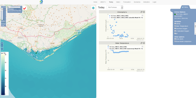
‘Today’ dashboard
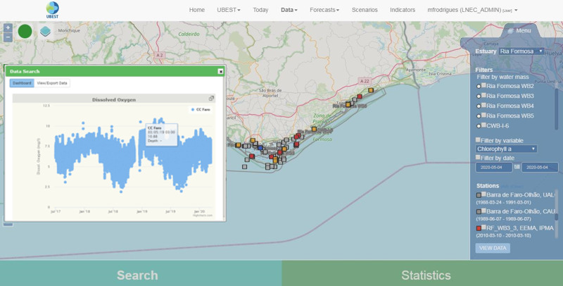
‘Data’ dashboard
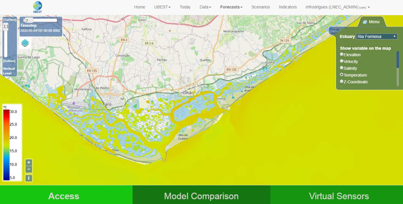
‘Forecasts’ dashboard
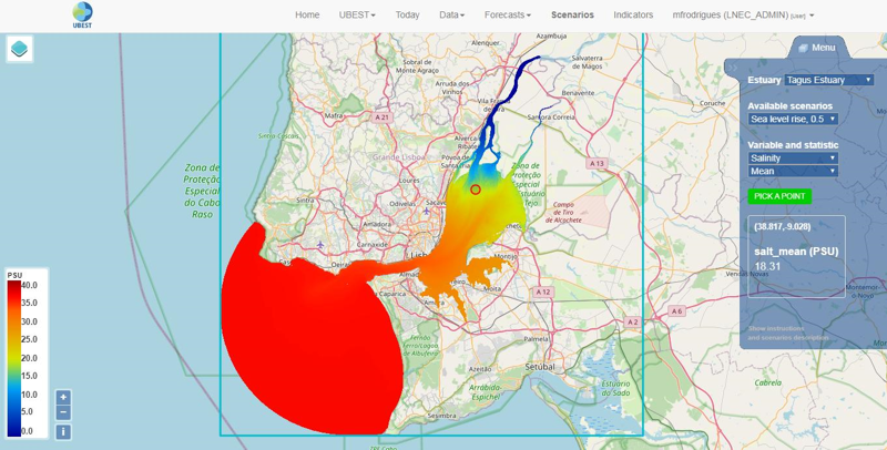
‘Scenarios’ dashboard
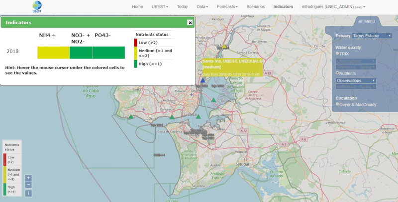
‘Indicators’ dashboard
Scientific Papers
Web-Based Observatory for Biogeochemical Assessment in Coastal Regions.
Rodrigues M, Martins R, Rogeiro J, Fortunato AB, Oliveira A, Cravo A, Jacob J, Rosa A, Azevedo A, Freire P A
2021, JOURNAL OF ENVIRONMENTAL INFORMATICS, [S.l.], p. 1-15, mar. 2021. ISSN 1684-8799, DOI
Temporal assessment of the water quality along an urban estuary (Tagus estuary, Portugal)
Rodrigues M, Cravo A, Freire P, Rosa A, Santos D
2020, Marine Chemistry, in press, DOI
Dissolved oxygen dynamics in Ria Formosa lagoon- a real time monitoring station observatory
Cravo A, Rosa A, Jacob J, Correia C
2020, Marine Chemistry, 223, DOI
OPENCoastS: An open-access service for the automatic generation of coastal forecast systems
Oliveira A, Fortunato AB, Rogeiro J., Teixeira J, Azevedo A, Lavaud L, Bertin A, Gomes J, David M, Pina J, Rodrigues M, Lopes P
2020, Environmental Modelling & Software, 124, 104585, DOI
Saltwater intrusion in the upper Tagus estuary during droughts
Rodrigues M, Fortunato AB, Freire P
2019, Geosciences. 9(9), 400, DOI
OPENCoastS: An open-access app for sharing coastal prediction information for management and recreation
Oliveira A, Rodrigues M, Rogeiro J, Fortunato AB
2019, In: Rodrigues J et al. (Eds) Computational Science – ICCS 2019. ICCS 2019. Lecture Notes in Computer Science, 11540, 794-807, DOI
High-performance computing applied to numerical models in UBEST
Martins R, Rogeiro J, Rodrigues M, Fortunato AB, Oliveira A, Azevedo A
2019, In: Abramowicz W, Paschke A (Eds), BIS 2018 International Workshops, LNBIP 339, 507-516, DOI
Influência dos sedimentos em suspensão no transporte e sobrevivência de E. coli no estuário do Tejo
Mendes S, Mesquita E, Rodrigues M, Menaia J
2019, Água& Resíduos, IV.5, 41-54, DOI
Plataforma interativa e integradora para previsão em tempo real e gestão do risco de inundação.
Oliveira A, Fortunato AB, Freire P, Rogeiro J, Azevedo A, Rodrigues M, David LM, Alves E, Mendes A, Teixeira J
2018, Recursos Hídricos, 39(1), DOI
Link:
Assessment of a three-dimensional baroclinic circulation model of the Tagus estuary (Portugal)
Rodrigues M, Fortunato AB
2017, AIMS Environmental Science, 4(6), 763-787, DOI
Communications in scientific events
Observatórios costeiros: ferramentas para apoiar a compreensão da capacidade de regulação biogeoquímica de estuários
Rodrigues M, Martins R, Rogeiro J, Cravo A, Fortunato AB, Oliveira A, Rosa A, Jacob J, Freire P, Azevedo A 2021, 15º Congresso da Água
Effects of climate change and anthropogenic pressures in the water quality of the Ria Formosa (Portugal)
Cravo A, Rosa A, Rodrigues M
2020, XX Seminário Ibérico de Química Marina (SIQUIMAR 2020)
Susceptibility of water quality indexes to tidal cycle and its effect on monitoring campaigns
Cereja R, Cruz J, Brotas V, Rodrigues M, Brito A
(2020, ECSA 58 - EMECS 13, Estuaries and coastal seas in the Anthropocene
The UBEST observatory: an innovative HPC-based portal for water quality management in coastal regions
Rodrigues M, Martins R, Rogeiro J, Oliveira A, Fortunato AB, Azevedo A, Freire P, Cravo A, Jacob J, Rosa A
2020, EOSC week 2020
Poster
OPENCoastS: on-demand forecast tool for management
Rodrigues M, Rogeiro J, Bernardo S, Oliveira A, Fortunato AB, Teixeira J, Lopes P, Azevedo A, Gomes J, David M, Pina J
2019, Proceedings of the Fourteen International Medcoast Congress on Coastal and Marine Sciences, Engineering, Management and Conservation - MEDCOAST 2019, Marmaris, Turkey
Towards an operational hydrodynamics and biogeochemical model of the Tagus estuary
Rodrigues M, Santos D, Rogeiro J, Fortunato AB, Teixeira J, Oliveira A, Martins R
2019, ISEM 2019 – The International Society for Ecological Modelling Global Conference 2019, Salzburg, Austria
Poster
Using HPC to enable coastal waters observatories
Rodrigues M, Oliveira A, Martins R, Rogeiro J, Santos D, Fortunato AB, Azevedo A
2019, IBERGRID 2019 - 10th Iberian Grid Conference, Spain
Tidal influence on the Phytoplankton community of Tagus estuary
Cereja R, Cruz J, Brito A, Rodrigues M, Brotas V
2019, EEF 2019 - 15th European Ecological Federation, Lisbon, Portugal
Dissolved oxygen dynamics in Ria formosa - a real time monitoring station approach
Cravo A, Rosa A, Jacob J, Correia C
2019, XV International Estuarine Biogeochemistry Symposium, Vigo, Espanha
Tagus Estuary Observatory: seasonal monitoring of the water quality
Rodrigues M, Cravo A, Freire P, Rosa A, Santos D
2019, XV International Estuarine Biogeochemistry Symposium, Vigo, Espanha
Poster
Water observatories as supporting tools to climate change adaptation in coastal ecosystems
Rodrigues M, Cravo A, Fortunato AB, Oliveira A, Martins R, Jacob J, Rogeiro J, Rosa A, Santos D, Freire P, Azevedo A
2019, ECCA2019 - 4th European Climate Change Adaptation conference, Lisbon, Portugal
Poster
Observatórios costeiros: integração em tempo real de previsões de circulação e da qualidade da água em sistemas de classificação
Rodrigues M, Fortunato AB, Rogeiro J, Santos D, Oliveira A, Martins R, Rosa A, Teixeira J, Jacob J, Cravo A, Azevedo A, Freire P
2019, IX Congresso sobre Planeamento e Gestão das Zonas Costeiras dos Países de Expressão Portuguesa, Lisboa, Portugal
Salinity dynamics in the upper Tagus estuary
Rodrigues M, Fortunato AB, Freire P
2019, Livro de resumos da 5ª Conferência de Morfodinânica Estuarina e Costeira, Lisboa, Portugal
Poster
Biogeochemical buffering capacity of Ria Formosa coastal lagoon
Rosa A, Correia C, Jacob J, Cravo A
2019, Encontro de Oceanografia 2019, Peniche, Portugal
Chemical characterization of Ria Formosa under Summer conditions of 2017
Rosa A, Correia C, Jacob J, Cravo A
2018, IX Symposium on the Iberian Atlantic Margin, Coimbra, Portugal
Characterization of the Ria Formosa water bodies in spring 2017
Rosa A, Correia C, Jacob J, Cravo A
2018, Seminario Ibérico de Química Marina (SIQUIMAR 2018), Vigo, Espanha
Better understanding of the biogeochemical buffering capacity of Ria Formosa, Portugal to future scenarios of global changes
Cravo A, Jacob J, Rosa A, Rodrigues M, Rogeiro J
2018, 2018 Ocean Sciences Meeting, Portland, EUA
One year monitoring of water characteristics inside Ria Formosa
Jacob J, Cravo A, Rosa A, Rodrigues M, Rogeiro J
2018, 5as Jornadas de Engenharia Hidrográfica, Lisboa, Portugal
Previsão em tempo real a pedido na Costa Portuguesa. O serviço OPENCoastS.pt e sua demonstração na circulação da Ria Formosa
Teixeira J, Fortunato AB, Rogeiro J, Azevedo A, Rodrigues M, Oliveira A
2018, Atas do 14º Congresso da Água, Évora, Portugal
Project UBEST - Understanding the biogeochemical buffering capacity of estuaries relative to climate change and anthropogenic inputs
Oliveira A
2018, Jornadas Tecnológicas 2018, Engenharia do Ambiente – FCT/UNL, Caparica, Portugal.
Variabilidade nas comunidades de fitoplâncton do estuário do Tejo devido aos ritmos de maré
Cereja R, Cruz J, Brito A, Rodrigues M, Brotas V
2018, 17º Encontro Nacional de Ecologia, Évora, Portugal
OPENCoastS.pt – Serviço de previsão em tempo real a pedido para a circulação e agitação marítima na costa Portuguesa
Teixeira J, Rogeiro J, Oliveira A, Fortunato AB, Azevedo A, Rodrigues M
2017, Atas das 9as Jornadas Portuguesas de Engenharia Costeira e Portuária, Lisboa, Portugal, 19pp.
Monitorização e previsão em estuários: ferramentas de apoio à gestão
Rodrigues M
2017, 2º Seminário: Estudo dos Cnidários, as ferramentas disponíveis, Lisboa, Portugal
UBEST: Compreensão da capacidade de regulação biogeoquímica dos estuários num contexto de alterações climáticas e das fontes antropogénicas
Rodrigues M, Cravo A, Fortunato AB, Oliveira A, Jacob J, Martins R, Rogeiro J, Azevedo A, Rosa A
2017, 4ª Conferência sobre Morfodinâmica Estuarina e Costeira – MEC2017, Porto, Portugal
Plataforma interativa e integradora para previsão em tempo real e gestão do risco de inundação
Oliveira A, Fortunato AB, Freire P, Rogeiro J, Azevedo A, Rodrigues M, David LM, Alves E, Mendes A, Teixeira J
2017, 7º Seminário APRH-Núcleo Regional Norte, V.N.Gaia, Portugal
Salinity evolution in the Tagus estuary relative to climate change
Rodrigues M, Fortunato AB, Freire P
2016, 4as Jornadas de Engenharia Hidrográfica, Lisboa, Portugal
Reports
Project UBEST: Understanding the biogeochemical buffering capacity of estuaries relative to climate change and anthropogenic inputs
Rodrigues M, Fortunato AB, Martins RJ, Rogeiro J, Oliveira A, Azevedo A, Freire P
Report 8, Calibration and validation of the 3D hydrodynamic model of the Ria Formosa. UBEST - Understanding the biogeochemical buffering capacity of estuaries relative to climate change and anthropogenic inputs
Rosa A, Jacob J, Rodrigues M, Fortunato A, Cravo A
Report 7, Field campaign UBEST7: Ria Formosa - April 9-10, 2019.
2019, Cravo A, Jacob J, Rosa A
UBEST Field Campaigns, 6th Campaign: Tagus Estuary, November 6, 2018
Santos D, Freire P, Rodrigues M, Cravo A
Field Campaigns, 5th Campaign: Tagus Estuary, September 27, 2018
Santos D, Freire P, Rodrigues M, Cravo A
UBEST Field Campaigns, 4th Campaign: Tagus Estuary, May 10, 2018
Santos D, Freire P, Fortunato AB, Cravo A
Report 5, Field campaign UBEST3: Ria Formosa – December 25-26, 2017. UBEST - Understanding the biogeochemical buffering capacity of estuaries relative to climate change and anthropogenic input
Cravo A, Jacob J, Rosa A
Report 4, Field campaign UBEST2: Ria Formosa - September 14-15, 2017. UBEST - Understanding the biogeochemical buffering capacity of estuaries relative to climate change and anthropogenic inputs
Cravo A, Jacob J, Rosa A
Report 3, Field campaign UBEST1: Ria Formosa - May 30-31, 2017. UBEST - Understanding the biogeochemical buffering capacity of estuaries relative to climate change and anthropogenic inputs
Cravo A, Jacob J, Rosa A
Report 2, Installation of the online water quality monitoring station in the Ria Formosa. UBEST – Understanding the biogeochemical buffering capacity of estuaries relative to climate change and anthropogenic inputs
Rodrigues M, Cravo A, Jacob J, Rosa A, Rogeiro J
Online monitoring in the Tagus Estuary: Parque das Nações station, Installation and operation between January 2016 and February 2017
Rodrigues M, Freire P, Rogeiro J, Fortunato AB
Report 1, Characterization of the study areas: Tagus estuary and Ria Formosa. UBEST - Understanding the biogeochemical buffering capacity of estuaries relative to climate change and anthropogenic inputs
Rodrigues M, Rosa A, Cravo A, Fortunato AB, Jacob J
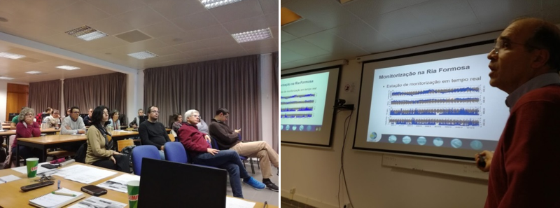
A final workshop was also held on December 13, 2020 at the University of Algarve.
Agenda and presentations of the workshop:
Agenda
Project overview
Monitoring network
Daily forecasts and impacts of climate change and anthropogenic pressures
UBEST web portal

Laboratório Nacional de Engenharia Civil
Marta Rodrigues (PI), André Fortunato, Anabela Oliveira, Paula Freire, Alberto Azevedo, João Rogeiro, Ricardo Martins, Joana Teixeira, Daniela Santos
Universidade do Algarve
Alexandra Cravo, José Jacob, Alexandra Rosa
Prof. António Melo Baptista (Oregon Health & Science University)
Project funded by the Fundação para a Ciência e a Tecnologia, PTDC/AAG-MAA/6899/2014.

Laboratório Nacional de Engenharia Civil
Av. do Brasil, 101
1700-066 LISBOA
PORTUGAL
Marta Rodrigues
218 443 613
Estuaries are among the most productive ecosystems on Earth and provide multiple ecosystem services. They harbour ecologically important habitats for fish, shellfish and birds and, due to their buffering capacity, protect the coastal ocean from increased nutrient loads and other terrestrial contaminants. Estuaries also support diverse human activities (e.g. marine transportation, fishing, tourism, and repository waters for domestic wastewater), providing economic resilience to coastal communities and protecting them from natural hazards. However, the predicted increase of human activities in estuaries, together with climate change, may increase the hazards in these systems and alter estuarine ecosystems dynamics. Climate change, such as sea level rise, represents a major threat to the world’s estuaries, via potential increases in salinity, acceleration in the nutrients cycling and disruption of aquatic ecosystems. Also, recent and predicted increases of nutrients loads to estuaries may exacerbate these impacts, leading to a decline of the regulating services provided by the estuaries (value estimated at 25847 Int$/ha/year), which include the estuarine buffering capacity.
The scientific goal of UBEST is to improve the global understanding of the biogeochemical buffering capacity of estuaries and its susceptibility to future scenarios of anthropogenic inputs and climate change. UBEST will effectively support the short and long-term management of these systems. This goal will be achieved by deploying “observatories”, which are emerging tools that integrate process-based numerical models and their results, and in-situ observations. To promote the generalization of the conclusions, two Portuguese case studies with very distinct characteristics will be assessed, the Tagus estuary and the Ria Formosa, a coastal lagoon.
The specific objectives of UBEST are:
i) the deployment of a monitoring network for biological and chemical parameters (e.g. chlorophyll-a, dissolved oxygen and nutrients) that will include an online biogeochemical station and a set of conventional stations;
ii) the implementation/improvement and validation of state-of-the-art, process-based, coupled hydrodynamic-biogeochemical models in each system;
iii) the quantification of the biogeochemical buffering capacity of each estuary under present conditions and for projected scenarios of sea level rise, changes in the hydrological regimes, air temperature and nutrients loads;
iv) the assessment of the estuarine physical and trophic conditions of the two estuaries under global classification metrics, and their comprehensive comparison with other estuaries worldwide.
UBEST involves a multidisciplinary team from Laboratório Nacional de Engenharia Civil (Coordination) and Universidade do Algarve, with complementary expertise in the fields of numerical modelling, in-situ data acquisition, laboratorial analyses and online data-model deployments.